 This is a drawing I did yesterday afternoon before my Drawing from the galleries class. This drawing is white and chsrcoal pencil on black paper. This drawing was done entirely from what I assumed an offshore drilling rig looks like as I did not have a reference image
Friday, June 25, 2010
Drawing: Offshore Drilling Rig under full moon
This is a drawing I did yesterday afternoon before my Drawing from the galleries class. This drawing is white and chsrcoal pencil on black paper. This drawing was done entirely from what I assumed an offshore drilling rig looks like as I did not have a reference image
Monday, June 21, 2010
Yearlings running
 3..2..1...
There is nothing like being able to photograph a full herd of horses. These are the yearlings from 2009 and prove to be a great study of running horses. The top image is my favorite. Click on this image to see a larger view.

 Why are they coming, It must be my camera.
Friday, June 18, 2010

Thursday, June 17, 2010

Monday, June 14, 2010
The Colors of Doc O Lena Twist: Two Foals
 Tut- Doc O Lena Twist x LS Shania Doc, owned by Karen Milan.
 Toby- Doc O Lena Twist x Cordura
Dam is Sorrel and both Toby and Cordura are owned by Austria Arnold

Tut was named after the King Tut Exhibit which was at the Dallas Museum of Art this past year.

Toby is trying to steal some Alfalfa from the mouth of my horse, Squirt. Cordura the Dam is in the center.
Friday, June 11, 2010
Equine Art: Mini Oil Pastels
 This is the Image which was my model
 3.5"x5" Oil Pastel on Ampersand Aquabord.
 3.5"x5" Oil Pastel on Ampersand Pastel Bord. The big challenge with these was depicting detail with such a broad stick of pastel.
Monday, June 07, 2010
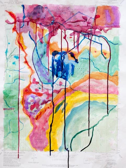
Map Art: McKinney Hills Watercolor Map

In anticipation of a map art project at the DMA Center for Creative Connections this coming Thursday, I found my Thesis Research Field Map and scanned it. I then gathered a number of field watercolors I did back in 1985 during my field work. I put these watercolors under a transparent layer of this field map, adding an important tool of the geologist, the Brunton Compass. I will take with me images of this map and the watercolors and see what comes of it this next Thursday.
Edit: I took this map project to the Creative Connections class and afterward ended up making a few minor changes. This is the updated map.
Thursday, June 03, 2010
Thursday at the DMA: Self Portrait using Office Materials
 Our assignment in the Center For Creative Connections tonight was to do a Self Portrait using common office materials. I did my Self Portrait on a green file folder using colored pencils, Paint marker and Liquid Paper correction fluid.
Subscribe to:
Posts (Atom)